We determined that the fault width values provided through the map interface to the QuakeTables fault database were incorrectly calculated. The underlying KML has been updated. This only applies to CGS 1996 and 2002 faults that were selected from the map interface, not to user-provided faults.
Wednesday, April 27, 2011
Tuesday, April 19, 2011
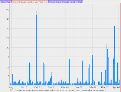
State change number plot in daily RDAHMM changed
We changed the state change number plot in daily RDAHMM portlets to use bars instead of lines, as shown in the following figure. The static png plots are also changed to use bars, and the plot for a bounded area is shown in a separate tab in stead of a new window.
For the Dygraph javascripts, we use the following options to achieve this effect:
{colors:['#007FFF'],
strokeWidth:0.7,
pixelsPerXLabel:50,
rightGap:2,
stepPlot:true,
fillGraph:true,
fillAlpha:0.8}
For the gnuplot scripts, we use the following two lines:
set style fill solid 1.0
plot "FILE" using 1:2 with boxes linetype 3
Daily RDAHMM updated to use LLH
We have changed the daily RDAHMM service and portlets so that they analyze and display LLH (longitude, latitude, height) time series data, instead of the NEU(north, east, up) data. We use the "Proj.4" application (http://trac.osgeo.org/proj/) to convert NEU data to LLH.
Monday, April 11, 2011
RDAHMM problems resolved, portal upgraded
Previously reported RDAHMM problems were resolved on March 15. Disloc, Simplex, and RDAHMM interfaces have also undergone several revisions and improvements.
Subscribe to:
Posts (Atom)